By Jennifer Jordan | Charleston Housing News
For more than a decade, Highway 41 has been one of the most talked-about — and least resolved — infrastructure challenges in the Charleston region. Now, Charleston County appears ready to move forward in a meaningful way, preparing to acquire portions of 172 properties as part of a long-awaited road expansion project east of the Cooper River.
On paper, this looks like progress. In reality, it’s something more complicated: a case study in how growth, infrastructure, and community identity continue to collide in one of the fastest-growing regions in the Southeast.
A $245 Million Solution to a $500 Million Problem
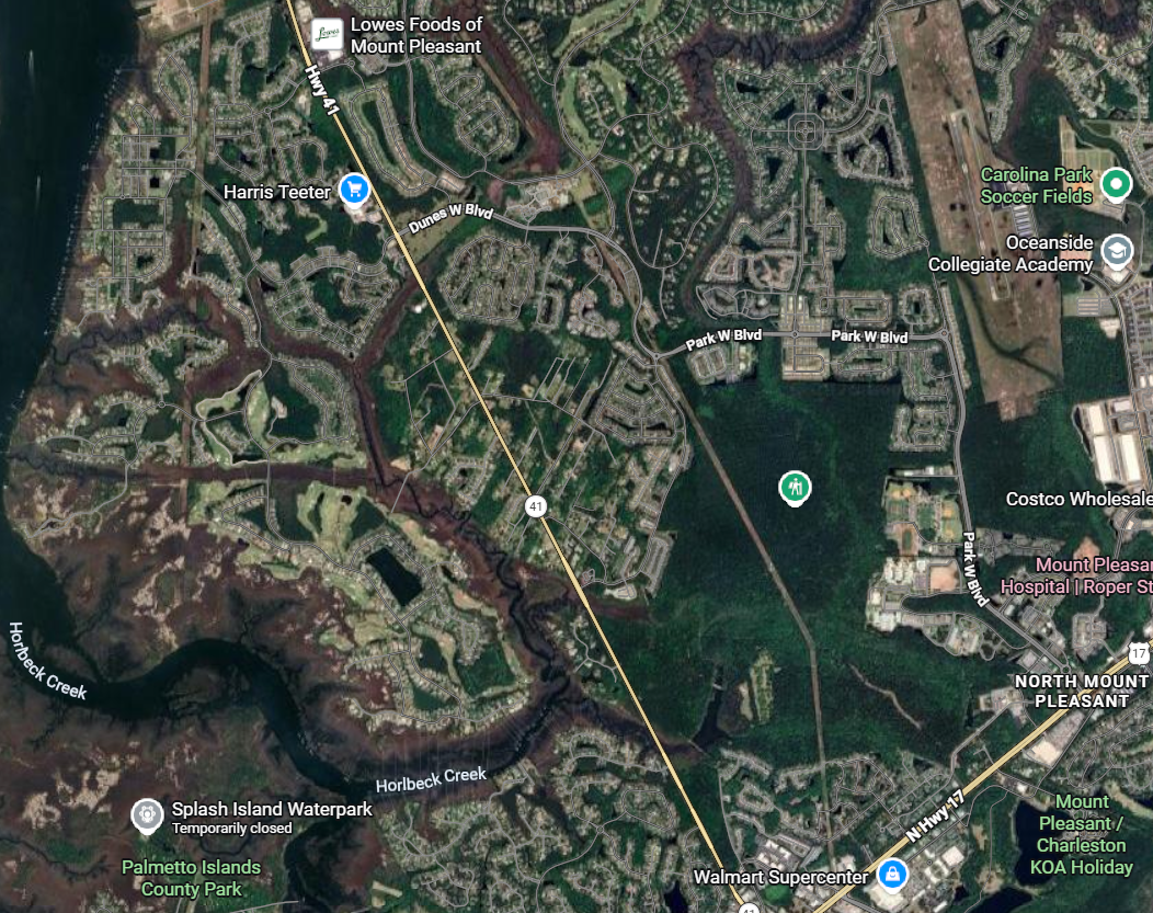
Highway 41 today is still largely a two-lane road stretching roughly five miles from the Wando River bridge to U.S. Highway 17. That might have worked decades ago when the area was rural. It does not work today.
Now, the corridor serves as a primary access route for major residential communities including Dunes West, Park West, Rivertowne, and Planter’s Pointe — thousands of homes funneling into a road network that was never designed to support them.
Traffic isn’t just bad — it’s predictably bad. And with continued development on both sides of the Cooper River, including the explosive growth on the Cainhoy Peninsula, it’s only getting worse.
The county’s plan, currently estimated at $245 million, would widen portions of Highway 41 to three or four lanes, add turn lanes, and introduce a connector road through the edge of Laurel Hill County Park.
Construction could begin as early as late 2026, assuming right-of-way acquisition and permitting stay on track.
But solving traffic here has never been just about engineering.
The “Road to Compromise” — And Why It Still Divides
The current plan is known as the “road to compromise,” a name that reflects years of political tension, community pushback, and competing priorities.
Earlier proposals would have widened Highway 41 more aggressively — in some cases up to five lanes — directly through the Phillips community, a historic Black settlement area dating back to the post-Civil War era.
That plan triggered significant backlash, with critics arguing it disproportionately impacted a historically underserved community.
In response, alternative proposals shifted the burden toward newer, higher-income subdivisions like Park West and Dunes West — which then generated their own opposition.
What emerged in 2021 was a scaled-back compromise:
- Less aggressive widening through Phillips
- A connector road partially through protected parkland
- Incremental improvements rather than a full-scale overhaul
Supporters say it’s the most balanced option available.
Critics say it’s insufficient — and delays the inevitable.
Eminent Domain: The Quiet Reality Behind the Plan
To move forward, Charleston County is preparing to use eminent domain where voluntary agreements can’t be reached.
Officials estimate roughly $9 million will be spent acquiring land rights, mostly narrow strips along existing roadways. Importantly, no homes are expected to be taken.
Still, eminent domain always introduces tension — especially in a region where property rights and land value are deeply personal.
And in Phillips, there’s an added layer of complexity.
The Heirs’ Property Problem No One Wants to Talk About
One of the most overlooked — and consequential — aspects of this project involves heirs’ property.
In many historic settlement communities like Phillips, land has been passed down through generations without formal wills or clear title. That means ownership is often legally unclear, even if families have occupied the land for decades.
Here’s the problem:
- If ownership can’t be legally established, compensation becomes difficult or impossible
- Resolving title issues can take years and significant legal expense
- Some families may lose land without ever receiving payment
It’s a structural issue, not a local one — but projects like Highway 41 bring it into sharp focus.
And despite the scale of the project, there’s currently no clear mechanism to solve it quickly.
Growth Is Winning — But At What Cost?
The deeper issue here isn’t just Highway 41.
It’s the broader reality of Charleston’s growth model.
For years, development has outpaced infrastructure:
- Large-scale subdivisions approved without corresponding road capacity
- Regional planning split across municipalities and counties
- Political reluctance to make hard decisions early
Now, the bill is coming due.
Residents in newer communities want relief from gridlock.
Historic communities want protection from displacement.
Environmental groups want preservation of land and ecosystems.
And local governments are trying to thread a needle that may not actually exist.
What Happens Next
Charleston County Council is expected to formally consider the property acquisitions — including the use of eminent domain — at a March 19 meeting.
If approved, the county will move closer to securing permits and finalizing right-of-way, with construction bids potentially going out later this year.
The project itself is expected to take up to four years to complete.
But even if everything goes perfectly, one thing is clear:
This project will not “fix” Highway 41.
It will improve it. It will make it safer. It will buy time.
But unless the region fundamentally changes how it aligns development with infrastructure, Highway 41 will remain what it has become — a symbol of Charleston’s success, and its growing pains.
Leave a Reply